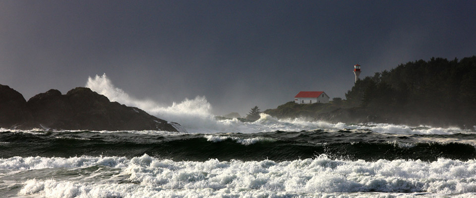
Storm Watching
Chesterman Beach B&B is a four-season retreat offering something for everyone all year round. In Winter time, you can take walks along the beach, tour the village shops and restaurants, or warm up by the fire with a book. If you're lucky, you might just catch one of the wild winter storms this part of the island is famous for - and you can be sure it will be a full-tilt, sensaround experience you won't soon forget!
 >
>
Storm watching has become a tourism phenomenon on the West Coast of Vancouver Island, though locals have been bracing against and surviving winter storms here for millennia. Storm watching, on the part of the observer, is predominantly a passive activity. It doesn't involve chasing water spouts or flying over the waves in a Zodiac boat. It doesn't really require anything of the observer but stillness and wonder.
Our oceanfront B&B is the best vantage point for these fantastic natural spectacles. A cozy spot by the fireplace and maybe a down duvet are all you really need to experience the fury and the force of the pounding Pacific Ocean on the other side of your rattling, double paned window. We'll even make sure there's a supply of candles nearby as the power is frequently knocked out during these storms.
When is Storm Watching best?
It's not easy to time a winter storm, but the season is generally October through to March with usually 10-15 good storms each month, with the peak months of December through February packing the most whoppers. It is during this season that Tofino receives the majority of it's nearly five meters of annual rainfall.

What makes a good Winter Storm?
Short answer: Prevailing winds. Winds here have been known to reach hurricane force (63 knots or better) and are often sustained at storm force (45 knots or better) or gale force (35 knots or better) conditions for several hours and sometimes days. The direction that the wind comes from will determine the severity of the storm. Winds coming from the southeast (called southeasterlies) off the ocean are the main ingredient for winter storms. Generally, low pressure systems move northward into the Gulf of Alaska in a curving motion and storm fronts spin southeast off this system toward Vancouver Island. A Gulf of Alaska low usually forms south of the Aleutian chain as a frontal wave between cold norther air and warmer air to the south. Such a wave may travel a considerable distance eastward before it begins to take shape as a low pressure system. Once the low starts to develop, pressures fall rapidly. At the same time, the low pressure system increases in size and wind speeds rise. The airflow is always counterclockwise around the low.
Click here to get a satellite view of the current weather sitting off the coast of Vancouver Island.
What are Winter Storms doing before they make landfall?
The low often deepens to 970 millibars, or lower, while moving northeast at 35 to 40 knots. The low usually reaches its lowest central pressure over the Gulf of Alaska. The front that extends southward from the low centre, sweeps over the coastal waters bringing with it southeasterly gale-to-storm force winds, rain and heavy seas. With the most active fronts, the wind can briefly rise to hurricane-force strength at places such as Solander Island, on the northern end of Vancouver Island. As the low moves further north over the Alaskan coast and the front crosses the B.C. coast, the storm enters its mature stage and begins to weaken. Ahead of the front, gale-to-storm force southeasterly winds often build the seas to 9 metres over the northern waters and to the west of Vancouver Island. In the most intense storms the seas can reach 10 to 12 metres. Even after the winds decrease, heavy ocean swells, typically from 4 to 6 metres, arrive at the coast up to 12 hours after the front has passed. These waves were formed with the strong west or northwest winds on the western flank of the low.
For up to the moment storm watching related information, visit the Environment Canada website.
Click here for Marine Weather information for the Central West Coast of Vancouver Island.